Tag: Nebraska Highways

  • NW LNK Improvement Sketches 3: Purple Heart Hwy West and an alternative to I-80

    NW LNK Improvement Sketches 3: Purple Heart Hwy West and an alternative to I-80

    I was recently in a situation where I was not allowed access to a computer, phone, books, etc. for several hours…but I had a couple pens and some handouts with blank backs! So for the next few weeks I will post these sketches. They are just some thoughts I’ve had about how I would improve roads in NW Lincoln. I did draw these 100% from memory; I did not alter anything afterward, and so once I look at satellite pics, that will probably nix some of my ideas. (Obviously not to scale for the same reasons.)

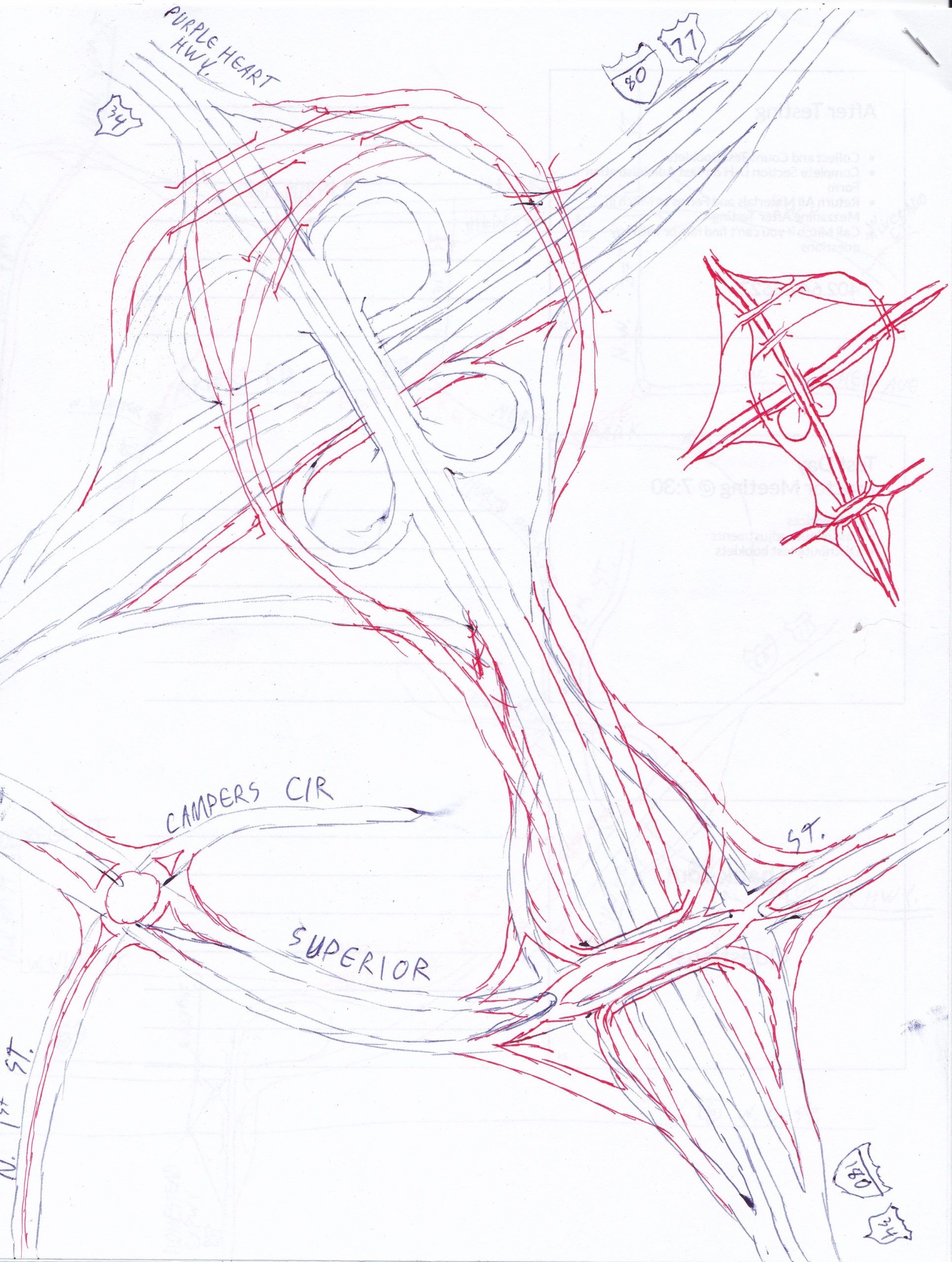
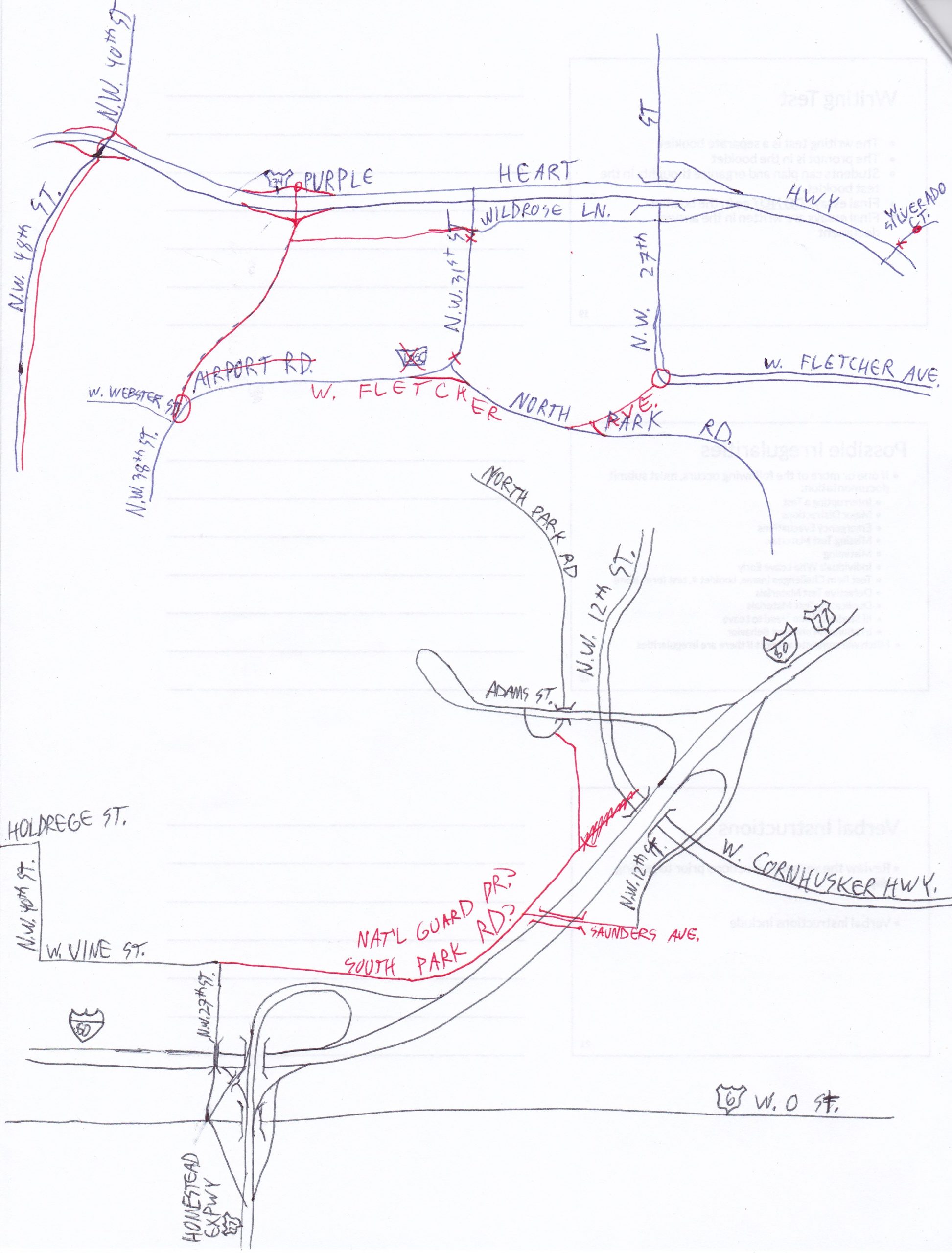
    The top sketch shows a continuation of the Purple Heart Hwy conversion to freeway that I started previously. There actually is a road that has been started that travels north from NW 38th St and Airport Rd, but the project seems to have been abandoned as far as I can tell. This finishes it and makes an interchange with Purple Heart Hwy, because making a left off of NW 31st St can get really interesting some days! I also show the NW 48th St project being completed (upgrade to four lanes) and connecting W Fletcher Ave to North Park Rd and Airport Rd so that one doesn’t have to go all the way up to Wildrose Ln and back down to get from Air Park to the Highlands. I also eliminate S55C from the highway roster, as it is now entirely within LNK city limits.

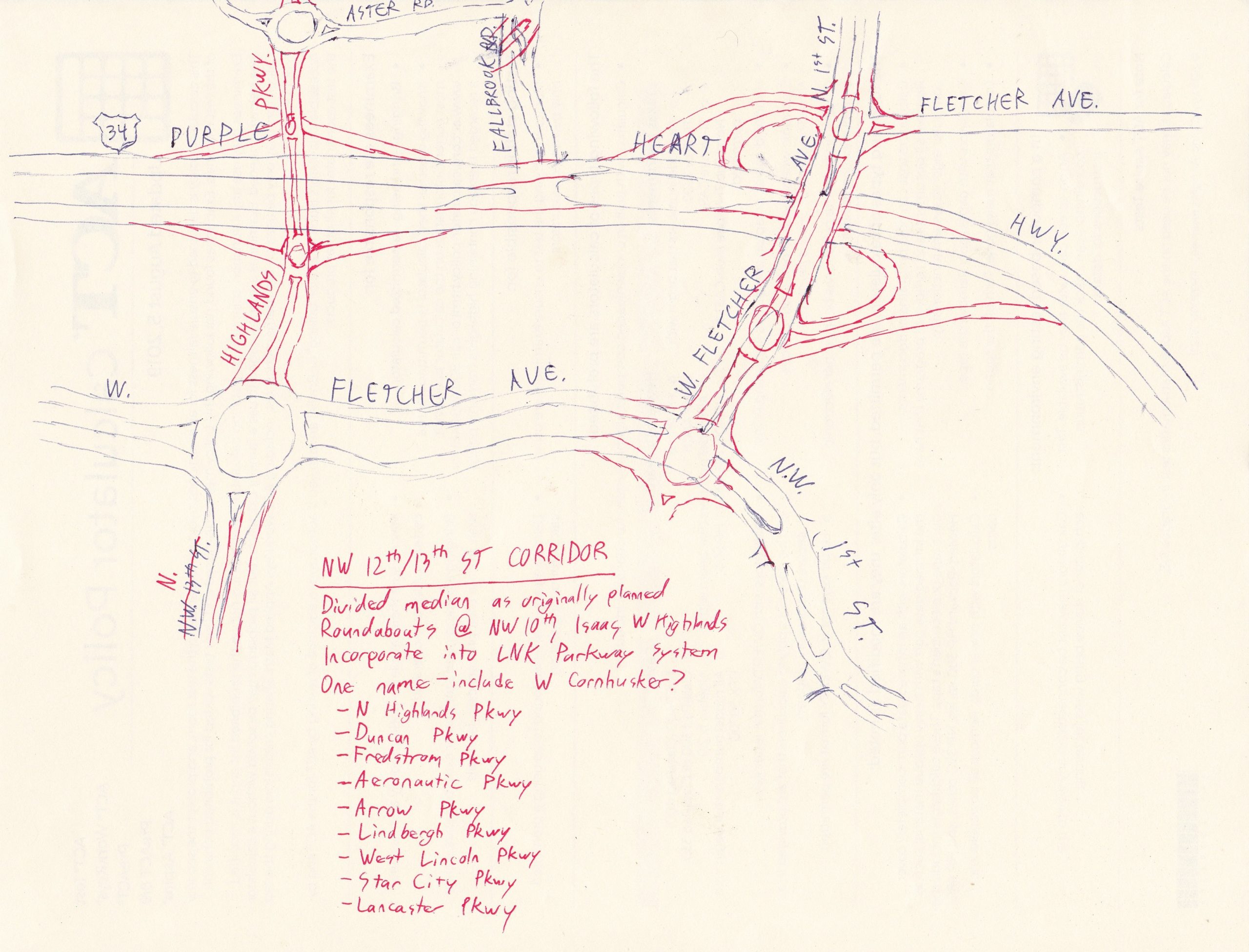
    One of my peeves of living in the Highlands is that there is not a good way to get down to US 6 to head west (also known as my non-interstate way to work) without either going all the way around the airport or backtracking to N 1st St to drop down to Sun Valley Blvd if you don’t want to take the interstate. So I proposed a surface road that would connect airport-area roads and NW 27th St along the north side of I-80. Of all of these sketches, this one is probably the least viable, because a) my working memory is slightly less here, b) protected salt marshes, and c) potentially national security issues with the National Guard right there (but at least I proposed that as a possible name?).

    That’s it for these sketches! If you liked them, let me know and maybe there will be similar content in the future!

  • NW LNK Improvement Sketches 2: I-180 @ I-80 and Superior Street

    NW LNK Improvement Sketches 2: I-180 @ I-80 and Superior Street

    I was recently in a situation where I was not allowed access to a computer, phone, books, etc. for several hours…but I had a couple pens and some handouts with blank backs! So for the next few weeks I will post these sketches. They are just some thoughts I’ve had about how I would improve roads in NW Lincoln. I did draw these 100% from memory; I did not alter anything afterward, and so once I look at satellite pics, that will probably nix some of my ideas. (Obviously not to scale for the same reasons.)

    This was an attempt to redesign the two interchanges at the north end of I-180. They are very close together (not meeting modern Interstate standards!) and it looks like some preliminary work may have been done when I-80 was widened to redo this, so I took what little I had and ran with it. In addition to hopefully eliminating the dangerous area between the two interchanges, I also eliminated the cloverleaves leading to and from I-180 to help improve downtown access (and Memorial Stadium on game day).

    I threw in a diverging diamond mostly for fun, although given that Superior Street is a primary route going east it might not be a bad idea to eliminate cross traffic turns.

  • NW LNK Improvement Sketches 1: Purple Heart Hwy & NW 12th/13th St Corridors

    NW LNK Improvement Sketches 1: Purple Heart Hwy & NW 12th/13th St Corridors

    I was recently in a situation where I was not allowed access to a computer, phone, books, etc. for several hours…but I had a couple pens and some handouts with blank backs! So for the next few weeks I will post these sketches. They are just some thoughts I’ve had about how I would improve roads in NW Lincoln. I did draw these 100% from memory; I did not alter anything afterward, and so once I look at satellite pics, that will probably nix some of my ideas. (Obviously not to scale for the same reasons.)

    For this one, I focused on Purple Heart Hwy and the NW 12th/13th St Corridor. My goal here was to convert Purple Heart Hwy to freeway–not interstate standard, though–out to N-79 (the western half will be shown later). This involved closing the Fallbrook Blvd intersection and converting W Fletcher Ave to an interchange (trying to avoid as many buildings as possible from memory); it also gives a roundabout at W Fletcher Ave/Fletcher Ave/N 1st St. I also put a roundabout at W Fletcher Ave and NW 1st St, because making a left turn there drives me crazy.

    There are currently long-term plans to build a bridge connecting the roundabouts at W Fletcher Ave and Aster Rd (I can’t wait!). I expanded this plan to include an interchange. One of my minor peeves is that NW 12th St becomes NW 13th St by Highlands Pool, and the new bridge will result in it rejoining the NW 12th St corridor. So I decided that these improvements would involve a consistent name from the south end of the I-80 interchange all the way to Aster Rd (where it would take the NW 12th St name). Renaming wouldn’t actually be too difficult; there are very few addresses on this stretch. I also threw out the consideration of including W Cornhusker Hwy in the renaming, since that is no longer a highway, never was part of US 77 (the original Cornhusker Hwy), and it is the same road, just curved to be E-W instead of N-S. If you can’t read my handwriting, I’ve listed the name ideas below with brief justification. I also said it should be part of the Lincoln Parkway system, which would also involve upgrading the section between W Highlands Blvd and W Fletcher Ave to a four lane divided street.

    • N Highlands Pkwy: It serves the Highlands. This is my favorite name, but to be fair we do have W Highlands Blvd on the south side of the residential Highlands
    • Duncan Pkwy: In honor of Duncan Aviation (as this is access to W Adams St to reach the airport) and a major Lincoln family
    • Fredstrom Pkwy: Matches the name of the nearby elementary school
    • Aeronautic Pkwy: Nearby airport
    • Arrow Pkwy: Named after a former airport of Lincoln. Has the added bonus of being a DC Comics reference (Lincoln’s nickname is the Star City, which is also the name of the Green Arrow’s city)
    • Lindbergh Pkwy: Supposedly Lindbergh learned how to fly at Arrow Airport.
    • West Lincoln Pkwy: This would be particularly good if W Cornhusker Hwy is included, as West Lincoln is served.
    • Star City Pkwy: Good name for the major road bringing people into Lincoln from the airport/US 34
    • Lancaster Pkwy: Honoring Lincoln’s original name, and goes roughly past the salt marshes.

    If you like this kind of stuff, let me know in the comments and maybe there will be more!

  • Intersections of Lincoln

    Intersections of Lincoln

    I came across Peter Gorman’s artwork of Omaha intersections, and to my knowledge no one has done this for Lincoln. It had been stewing in my brain for a while, so I finally decided to pick up my (digital) pen and draw it myself. I think I’m going to make a poster and a T-shirt of it for myself. At this moment, Spoofy Randomness doesn’t have a store so I doubt if it will be printed up for general consumption, unless there’s significant demand. (And yes, it’s copyrighted, ya dang internet scalpers!)

    Choosing which intersections to include was a bit tricky, so if your favorite didn’t make the cut, sorry. I decided no freeway interchanges fairly quickly, and it had to be in Lincoln city limits. Runners-up included 56th/Cotner/Randolph, Cotner/66th/Starr, Cotner/Adams/66th (Cotner is very unique, okay?), W Fletcher/NW 13th, 14th/Superior, Capitol/Randolph/G, Pine Lake/91st, 84th/Yankee Hill/Yankee Woods, Fallbrook/Tallgrass, and 33rd/Sheridan. I actually had finished drawing 56th/Cornhusker/Havelock/Superior/Touzalin/Russell when I realized that I had not included Rosa Parks Way, so it got eliminated because I had another Cornhusker intersection less than a mile away and there were too many road names involved.

    A couple interesting (well, let’s be honest, interesting for me and not many others) bits of trivia from this map. First, the top left does not include Pinnacle Arena Dr in the title. There’s some debate as to when Salt Creek Rdwy ends and Pinnacle Arena Dr begins. A lot of maps have it at the left roundabout, but the signage actually shows the change occurring at N 8th St. Being an OpenStreetMaps guy, I follow the rule of signage, hence that decision. The other unusual choice I had to make was Nebraska Parkway’s name (top middle). Currently, it is actually Nebraska Highway, but very soon (in construction terms, 2024ish) it will have a name change to Nebraska Parkway as N-2 will be rerouted onto the new south leg of the beltway and Nebraska Highway will join Lincoln’s parkway system as Business N-2, hence the renaming. By doing this, this also allowed me to feature every parkway (yes Rosa Parks Way is actually part of the parkway system, and yes, it is a glorious pun) in some form. Also, yes, there are a few side streets that connect that aren’t shown. Artistic liberty. Same goes with scaling (especially on O Street).

    I wanted something unique, other than a different style of artwork, to set my work off from Gorman’s. Hence, including O Street (despite technically not being an intersection). While technically it has five names (Road 9, O Street Road, West O Street, O Street, and East Union Road, and also designated the Bess Streeter Aldritch Memorial Highway for a stretch), it is arguably the longest stretch of straight Main Street in the world (there’s some debate on this matter), with no curves between south of Waco to the Missouri River, and 9 Rd after a slight curve continues west almost to Grand Island.

    On a non-road geek note, this art had me tinker with some things that I didn’t really do with webcomics. My biggest problem was how to make the road widths consistent. This led to a rabbit hole that never really answered my question (I just drew a thick line over a screenshot of the map and outlined it on a new layer, then discarded the layers with the thick lines and the map), but did introduce me to the world of vectors and how to use them in Clip Studio. WHY DID I NOT LEARN HOW TO DO THIS WHEN I WAS MAKING COMICS????? Man, that would have made life so much easier. (I was aware vectors were a thing, but didn’t know much about them. Remember, I never took art after 6th grade, and I was still on an Apple IIGS then…)

  • The Great Nebraska Highway Revision Project

    As you may have seen on Twitter, I have a new pet project that I am hosting on this site, one that really has nothing to do with Spoofy Randomness.  A side hobby of mine (I swear, my hobby is collecting hobbies) is studying maps.  As a result, I have found several odd quirks in Nebraska’s otherwise fine road system.  This project, linked by the 67C Spur shield to the right, is me fantasizing about what I would do with Nebraska’s highway system if I could.  So far, I don’t have a lot in it, but keep watching as it grows!